
Steamboat's dry spell breaks this weekend, with a second storm possible before opening day
Rain and mountain snow are forecast Saturday, with light totals near Steamboat, and a second storm is possible midweek, though forecasters' confidence in it is very low. Steamboat Resort's scheduled opening is Saturday, Nov. 21.


Key points
- The National Weather Service expects dry, warmer-than-normal weather through Friday, then "a period of unsettled weather" this weekend and an "unsettled pattern" next week.
- Saturday's storm is forecast to bring rain and snow showers to town and less than an inch of snow on the mountains around Steamboat, by the Independent's tally of Weather Service forecast grids.
- A second storm could bring more snow: about 2 to 4 inches on the mountains around Steamboat from late Tuesday to early Thursday, by the Independent's tally of the grids, though forecasters call their confidence in it "very low."
- Federal outlooks for Nov. 17 to 21 and Nov. 19 to 25 tilt the odds toward above-normal precipitation for Colorado as a whole; both windows include Steamboat Resort's scheduled Nov. 21 opening.
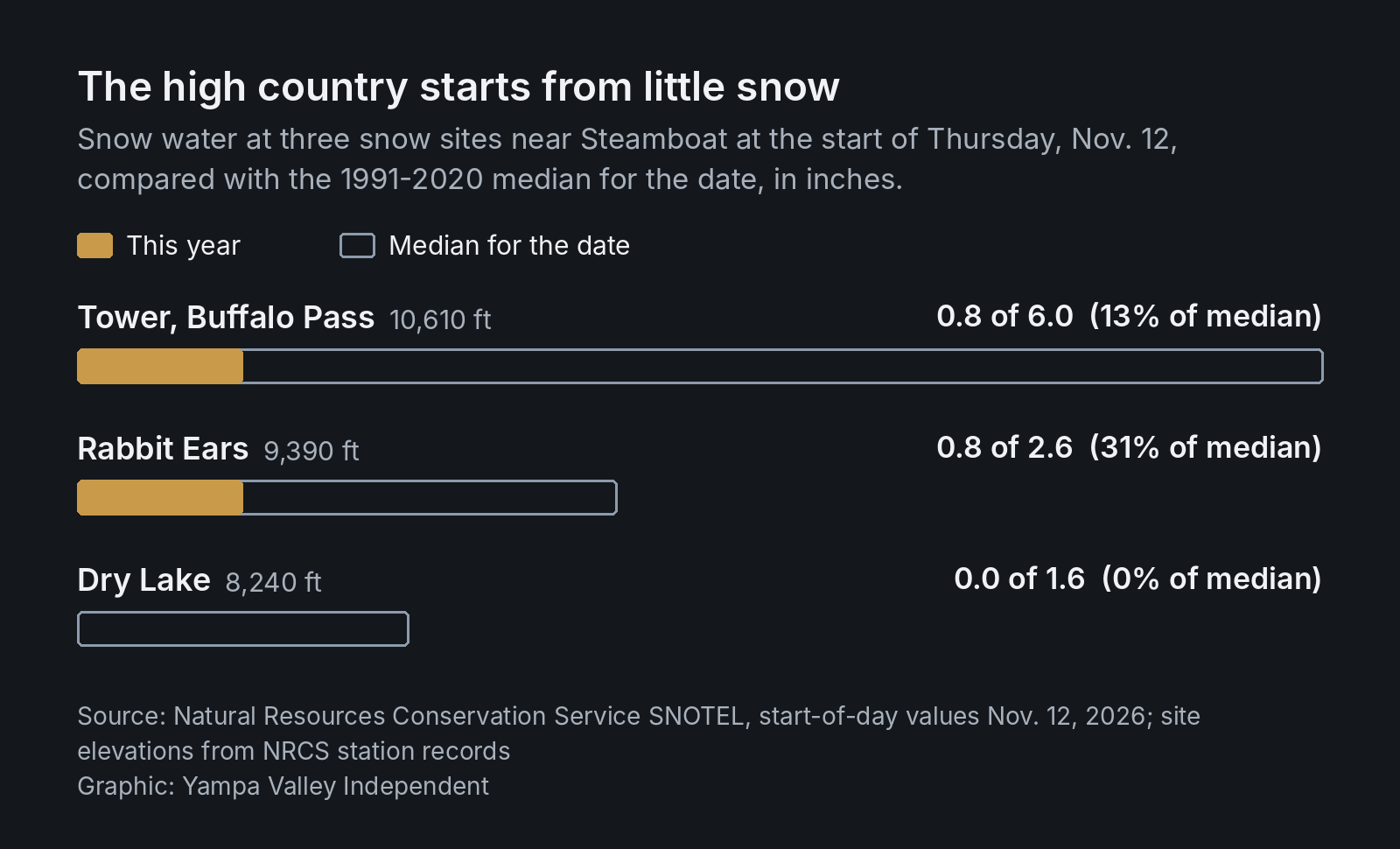
- The high country is starting from little snow: the Tower snow site on Buffalo Pass held 13% of its median snowpack for the date at the start of Thursday.
Steamboat Springs' weather is about to turn.
The National Weather Service office in Grand Junction expects dry weather and temperatures 5 to 10 degrees above normal through Friday. Then, forecasters wrote, "a period of unsettled weather arrives this weekend and beyond." Forecasters see one storm Saturday and another possible by midweek, with the pattern staying unsettled next week.
Steamboat Resort's mountain report on Thursday listed its "scheduled Opening Day on Saturday, November 21," with all 23 lifts and 184 trails still closed and no new snow in the past 48 hours. The high country's snowpack is well below the median for the date.
Saturday: rain in town, snow up high
In town, the Weather Service's forecast calls for a chance of rain showers after 11 a.m. Saturday, mixing with snow after 5 p.m., with a high near 52. Rain and snow showers are likely Saturday night, mainly before 11 p.m., with a low around 29.
On the mountain, the forecast point at 8,934 feet, about 3 miles east-southeast of town, calls for a 40% chance of snow showers, mainly after 11 a.m., and likely snow showers Saturday night.
Steamboat isn't the bullseye this time. Forecasters say the storm favors the southern mountains; model data they cited show better than an 80% chance of 6 inches or more in the San Juans above 9,000 to 10,000 feet. By the Independent's tally of the Weather Service's forecast grids, Saturday into early Sunday adds up to 0.2 to 0.6 inch of snow between about 8,900 and 10,000 feet around Steamboat, and no accumulation in town. Forecasters expect snow levels to drop to around 7,000 feet late Saturday night, just above the town's elevation of about 6,700 feet, as precipitation chances wind down, though lingering showers could bring light snow to lower elevations through early Sunday morning.
Forecasters in Grand Junction wrote that "slippery to hazardous travel is likely over mountain passes with reduced visibility while it's snowing." As of 11:10 a.m. Thursday, the office had no watches, warnings or advisories in effect for Colorado. Check road conditions before crossing Rabbit Ears Pass this weekend.
Midweek: a possible second storm
In town, a chance of rain and snow showers returns Tuesday night, followed by rain and snow showers Wednesday with a high near 46. By the Independent's tally, the grids add up to 2.1 to 4.4 inches on the mountains around Steamboat from late Tuesday to early Thursday, and about an inch in town.
That storm is far from settled. Forecasters called their confidence "very low" because of sizable differences in its timing, strength and track, though current trends point to a fast-moving storm arriving Tuesday evening.
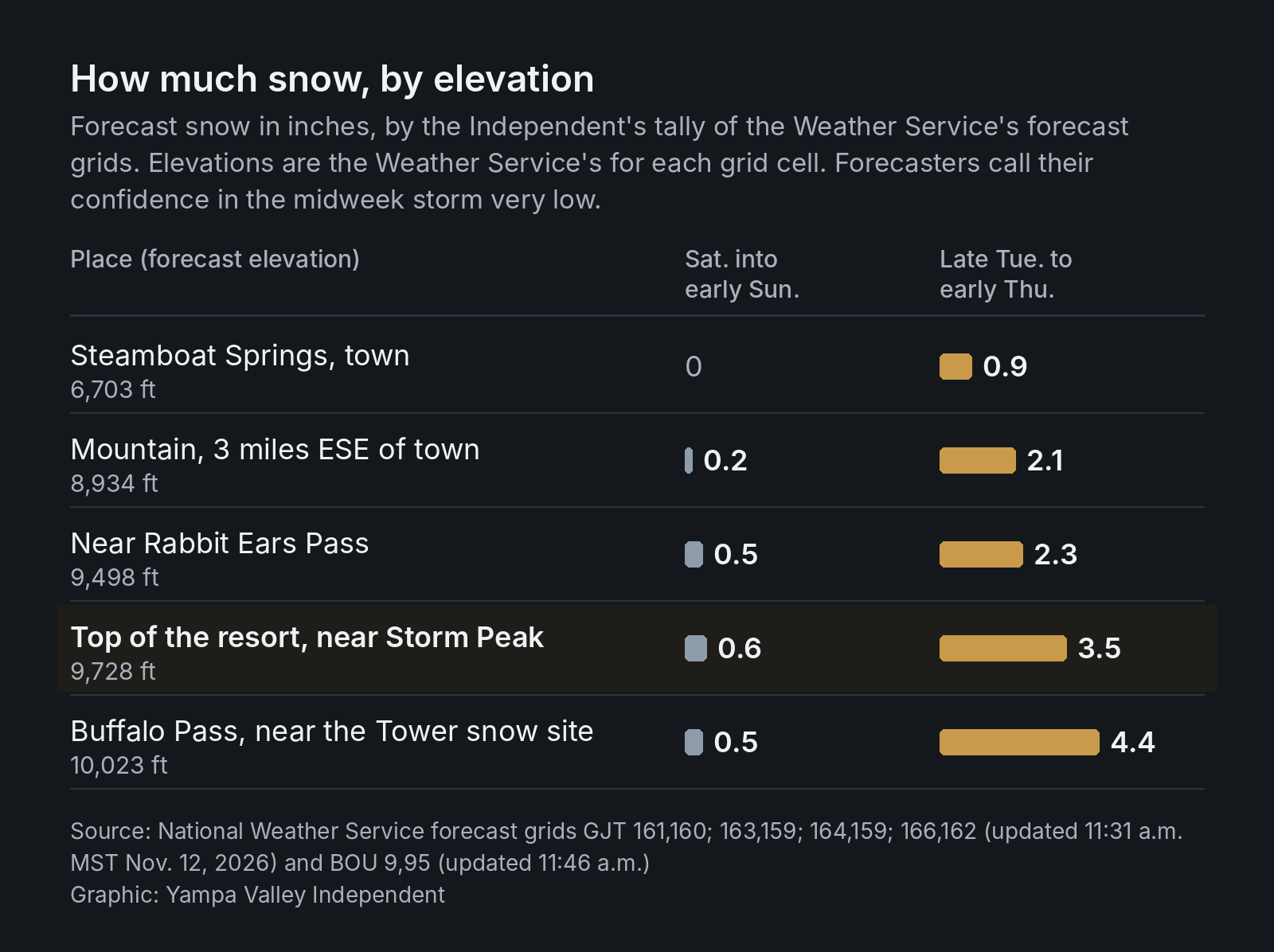
The top-of-the-resort figures are for the Weather Service's forecast grid cell near the Storm Peak Laboratory weather station, a spot its forecast page calls 4 miles east-southeast of Steamboat Springs. The Weather Service puts the cell at 9,728 feet; the station sits at 10,531 feet.
Up high: the week ahead at the top of the resort
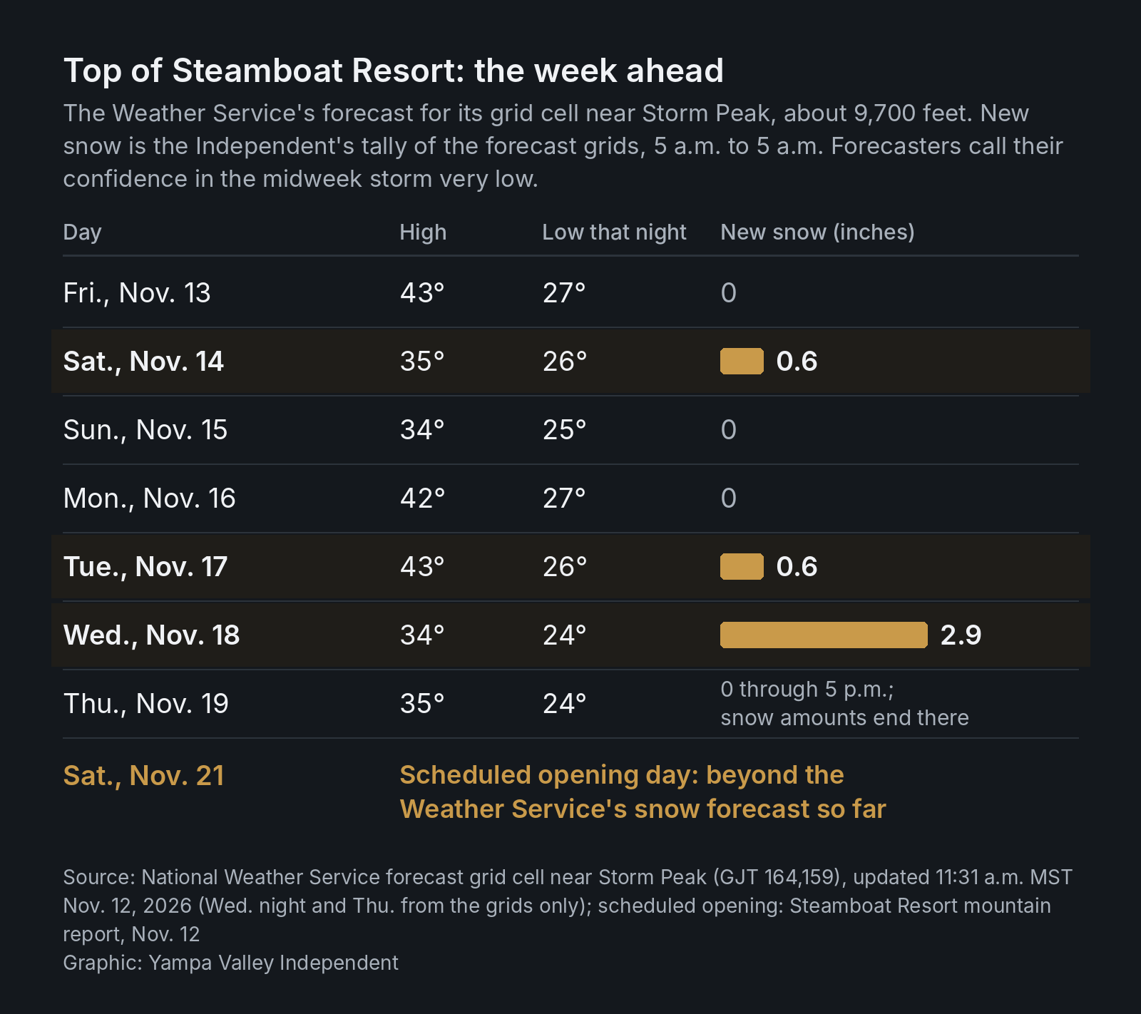
The top of the resort runs much colder than town: Friday's forecast high there is 43, against 58 in town. The Weather Service's forecast grid cell near Storm Peak calls for a high of 43 Friday, 35 and 34 Saturday and Sunday, 42 and 43 Monday and Tuesday, and 34 and 35 Wednesday and Thursday, with lows of 24 to 27. By the Independent's tally of that cell's snow grids, the weekend storm adds up to 0.6 inch Saturday into early Sunday, and the midweek storm to 3.5 inches from late Tuesday to early Thursday, 2.9 of them from Wednesday morning to early Thursday. The Weather Service's worded forecast for the same cell gives ranges instead: 1 to 3 inches possible Tuesday night, 2 to 4 inches Wednesday and around an inch Wednesday night.
Into opening week
The longer outlooks lean wet. The federal Climate Prediction Center's outlooks, issued Wednesday, tilt the odds toward above-normal precipitation for Colorado as a whole from Nov. 17 to 21 and from Nov. 19 to 25. Forecaster Thomas Collow tied the wetter odds to upper-level disturbances moving inland over the West, with the highest odds over the Four Corners and Southwest. The same outlooks favor above-normal temperatures in Colorado for Nov. 17 to 21 and near-normal temperatures for Nov. 19 to 25. The Weather Service's seven-day point forecasts run through Wednesday, Nov. 18, and its snow grids through Thursday, so neither covers opening day yet.
The mountains are waiting
At the Tower snow site on Buffalo Pass, 10,610 feet up, the snowpack held 0.8 inch of water Thursday morning, 13% of the 1991-2020 median for the date, with 2 inches of snow on the ground, according to the Natural Resources Conservation Service. The Rabbit Ears site was at 31% of median, after slipping from 1.0 inch of water on Nov. 6 to 0.8 inch Thursday, and the Dry Lake sensor has read zero since Tuesday.
What's next
- This weekend: rain and mountain snow Saturday into early Sunday.
- Midweek: a possible second storm late Tuesday to early Thursday; very low confidence for now.
- Opening day: Steamboat Resort's scheduled opening is Saturday, Nov. 21.
- Forecast updates: forecasters said there "will likely be refinements made to the rain and snow forecasts" for the weekend storm; the figures above are from Thursday's forecast.
- Snowpack: NRCS posts new readings each morning; the Independent's Nov. 4 story, San Juan snow sites set early-November records; Steamboat's snowpack is just beginning, has the season so far.
Sources
- National Weather Service, 7-day forecast for Steamboat Springs (6,703 ft), last update 11:31 a.m. MST Nov. 12.
- National Weather Service, 7-day forecast 3 miles ESE of Steamboat Springs (8,934 ft), last update 11:31 a.m. MST Nov. 12.
- National Weather Service, 7-day forecast 4 miles ESE of Steamboat Springs (top of the resort, near Storm Peak; 9,728 ft), last update 11:31 a.m. MST Nov. 12, and the same grid cell's text forecast on api.weather.gov.
- National Weather Service Grand Junction, Area Forecast Discussion, issued 11:10 a.m. MST Nov. 12 (discussion section 10:53 a.m.).
- National Weather Service forecast grids (api.weather.gov), snowfall amounts for grid points GJT 161,160; GJT 163,159; GJT 164,159 (top of the resort, with its temperatures); GJT 166,162 (updated 11:31 a.m. MST Nov. 12) and BOU 9,95 (updated 11:46 a.m. MST Nov. 12); summed by the Independent.
- Natural Resources Conservation Service, SNOTEL Report Generator, start-of-day values Nov. 6 to 12 for Tower (825), Rabbit Ears (709) and Dry Lake (457), with 1991-2020 medians.
- Steamboat Resort, Mountain Report, read Nov. 12 at 10:50 a.m. and 12:23 p.m. MST.
- NOAA Climate Prediction Center, 6-10 and 8-14 Day Prognostic Discussions, issued 3 p.m. EST Nov. 11 (outlook tables for Nov. 17-21 and Nov. 19-25).